A class for managing GeoTiff images. More...
#include <GeoImageGeoTiff.h>
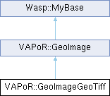
Inheritance diagram for VAPoR::GeoImageGeoTiff:

Public Member Functions | |
| GeoImageGeoTiff () | |
| virtual | ~GeoImageGeoTiff () |
| int | Initialize (string path, vector< double > times) |
| unsigned char * | GetImage (size_t ts, size_t &width, size_t &height) |
| unsigned char * | GetImage (size_t ts, const double pcsExtentsReq[4], string proj4StringReq, size_t maxWidthReq, size_t maxHeightReq, double pcsExtentsImg[4], double geoCornersImg[8], string &proj4StringImg, size_t &width, size_t &height) |
 Public Member Functions inherited from VAPoR::GeoImage Public Member Functions inherited from VAPoR::GeoImage | |
| GeoImage () | |
| GeoImage (int pixelsize, int nbands) | |
| virtual | ~GeoImage () |
| virtual int | Initialize (string path, std::vector< double > times)=0 |
| virtual unsigned char * | GetImage (size_t ts, size_t &width, size_t &height)=0 |
| virtual unsigned char * | GetImage (size_t ts, const double pcsExtentsReq[4], string proj4StringReq, size_t maxWidthReq, size_t maxHeightReq, double pcsExtentsImg[4], double geoCornersImg[8], string &proj4StringImg, size_t &width, size_t &height)=0 |
 Public Member Functions inherited from Wasp::MyBase Public Member Functions inherited from Wasp::MyBase | |
| MyBase () | |
| const string & | getClassName () const |
Additional Inherited Members | |
 Public Types inherited from Wasp::MyBase Public Types inherited from Wasp::MyBase | |
| typedef void(* | ErrMsgCB_T) (const char *msg, int err_code) |
| typedef void(* | DiagMsgCB_T) (const char *msg) |
 Static Public Member Functions inherited from Wasp::MyBase Static Public Member Functions inherited from Wasp::MyBase | |
| static void | SetErrMsg (const char *format,...) |
| Record a formatted error message. | |
| static void | SetErrMsg (int errcode, const char *format,...) |
| Record a formatted error message and an error code. | |
| static const char * | GetErrMsg () |
| static void | SetErrCode (int err_code) |
| Record an error code. | |
| static int | GetErrCode () |
| Retrieve the current error code. | |
| static void | SetErrMsgCB (ErrMsgCB_T cb) |
| static ErrMsgCB_T | GetErrMsgCB () |
| static void | SetErrMsgFilePtr (FILE *fp) |
| static const FILE * | SetErrMsgFilePtr () |
| static void | SetDiagMsg (const char *format,...) |
| Record a formatted diagnostic message. | |
| static const char * | GetDiagMsg () |
| static void | SetDiagMsgCB (DiagMsgCB_T cb) |
| static DiagMsgCB_T | GetDiagMsgCB () |
| static void | SetDiagMsgFilePtr (FILE *fp) |
| static bool | EnableErrMsg (bool enable) |
| static bool | GetEnableErrMsg () |
 Static Public Attributes inherited from Wasp::MyBase Static Public Attributes inherited from Wasp::MyBase | |
| static char * | ErrMsg |
| static int | ErrCode |
| static int | ErrMsgSize |
| static FILE * | ErrMsgFilePtr |
| static ErrMsgCB_T | ErrMsgCB |
| static char * | DiagMsg |
| static int | DiagMsgSize |
| static FILE * | DiagMsgFilePtr |
| static DiagMsgCB_T | DiagMsgCB |
| static bool | Enabled |
 Protected Member Functions inherited from VAPoR::GeoImage Protected Member Functions inherited from VAPoR::GeoImage | |
| int | TiffOpen (string path) |
| void | TiffClose () |
| int | TiffGetImageDimensions (int dirnum, size_t &width, size_t &height) const |
| int | TiffReadImage (int dirnum, unsigned char *texture) const |
| TIFF * | TiffGetHandle () const |
| int | CornerExtents (const double srccoords[4], double dstcoords[4], string proj4src) const |
 Protected Member Functions inherited from Wasp::MyBase Protected Member Functions inherited from Wasp::MyBase | |
| void | SetClassName (const string &name) |
 Protected Attributes inherited from VAPoR::GeoImage Protected Attributes inherited from VAPoR::GeoImage | |
| int | _pixelsize |
| int | _nbands |
Detailed Description
A class for managing GeoTiff images.
Definition at line 23 of file GeoImageGeoTiff.h.
Constructor & Destructor Documentation
◆ GeoImageGeoTiff()
| VAPoR::GeoImageGeoTiff::GeoImageGeoTiff | ( | ) |
◆ ~GeoImageGeoTiff()
|
virtual |
Member Function Documentation
◆ GetImage() [1/2]
|
virtual |
Fetch a georeferenced image
- Parameters
-
[in] ts time step [in] pcsExtentsReq A four-element array containing the extents (llx, lly, urx, ury) of the requested region in Projected Coordinates. [in] proj4StringReq The Proj4 string that maps lat-long coordinates into the PCS coordinates used in pcsExtentsReq.[in] maxWidthReq The requested maximum width in pixels of the returned image [in] maxHeightReq The requested maximum height in pixels of the returned image [out] pcsExtentsImg A four-element array containing the extents (llx, lly, urx, ury) of the returned image map in Projected Coordinates of the image. [out] geoCornersImg An eight-element array containing the corner points (llx, lly, ulx, uly, urx, ury, lrx, lry) of the returned image map in Geographic coordinates [out] width The actual width in pixels of the returned image [out] height The actual height in pixels of the returned image
- Return values
-
image Upon success at 2D texture with n channels (See GeoImage::GeoImage()) is returned. Memory for the returned image is managed by the class, and should not be freed.
Implements VAPoR::GeoImage.
◆ GetImage() [2/2]
|
virtual |
Fetch a non-georeferenced image
Return an image without any geo-referencing information.
- Parameters
-
[in] ts time step of image [out] width Width in pixels of returned image [out] height Height in pixels of returned image
- Return values
-
image Upon success at 2D texture with n channels (See GeoImage::GeoImage()) is returned. Memory for the returned image is managed by the class, and should not be freed.
Implements VAPoR::GeoImage.
◆ Initialize()
| int VAPoR::GeoImageGeoTiff::Initialize | ( | string | path, |
| vector< double > | times | ||
| ) |
The documentation for this class was generated from the following file:
- /Users/pearse/VAPOR/include/vapor/GeoImageGeoTiff.h