This dataset covers the same 671 catchments as the Large-Sample Hydrometeorological Dataset introduced by Newman et al. (2015). For each catchment, we characterized a wide range of attributes that influence catchment behavior and hydrological processes. Datasets characterizing these attributes have been available separately for some time, but comprehensive multivariate catchment scale assessments have so far been difficult, because these datasets typically have different spatial configurations, are stored in different archives, or use different data formats. By creating catchment scale estimates of these attributes, our aim is to simplify the assessment of their interrelationships.
Topographic characteristics (e.g. elevation and slope) were retrieved from Newman et al. (2015). Climatic indices (e.g., aridity and frequency of dry days) and hydrological signatures (e.g., mean annual discharge and baseflow index) were computed using the time series provided by Newman et al. (2015). Soil characteristics (e.g., porosity and soil depth) were characterized using the STATSGO data set and the Pelletier et al. (2016) data set. Vegetation characteristics (e.g. the leaf area index and the rooting depth) were inferred using MODIS data. Geological characteristics (e.g., geologic class and the subsurface porosity) were computed using the GLiM and GLHYMPS data sets.
An essential feature, that differentiates this data set from similar ones, is that it both provides quantitative estimates of diverse catchment attributes, and involves assessments of the limitations of the data and methods used to compute those attributes (see Addor et al., 2017). The large number of catchments, combined with the diversity of their geophysical characteristics, makes this new data well suited for large-sample studies and comparative hydrology.
The hydrometeorological time series provided by Newman et al. (2015) together with the catchment attributes described here constitute the CAMELS data set: Catchment Attributes and MEteorology for Large-sample Studies.
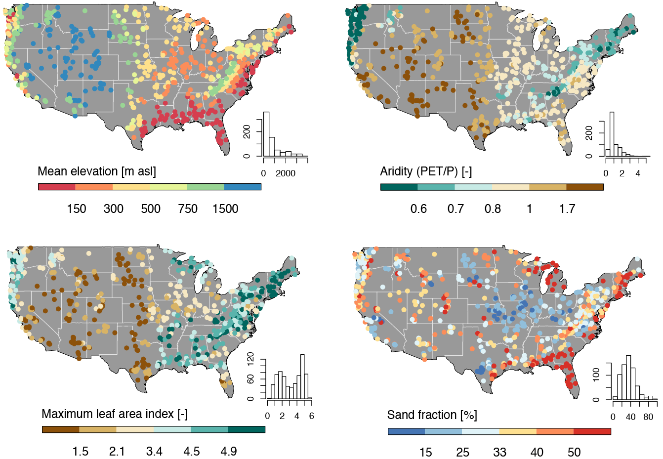
Figure. Four examples of attributes characterized over the contiguous United States.
Release date: 2017, last updated October 2017
Versions: 2.0, available
Access information: freely available at https://ral.ucar.edu/solutions/products/camels
How to cite this resource:
Format/size: ascii files, 1 MB
Coverage: 671 watersheds across contiguous US
Dataset details: Addor et al., HESS, 2017
NCAR: Martyn Clark (PI), Nans Addor, Andrew Newman, Naoki Mizukami
Contact: Nans Addor | naddor@ucar.edu
U.S. Army Corps of Engineers
Related project information: meteorological_datasets
Related datasets: CAMELS_timeseries
Related Papers:
3450 Mitchell Ln
Boulder, Colorado 80301
United States