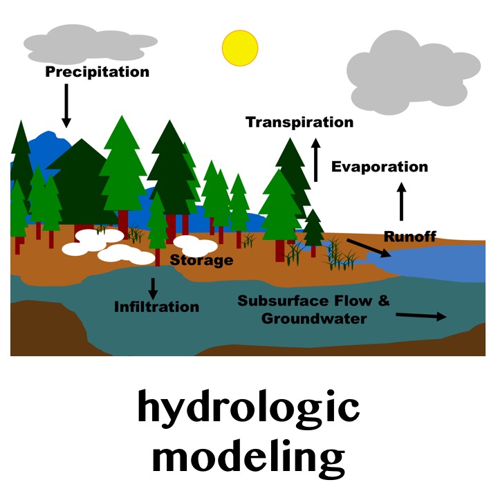
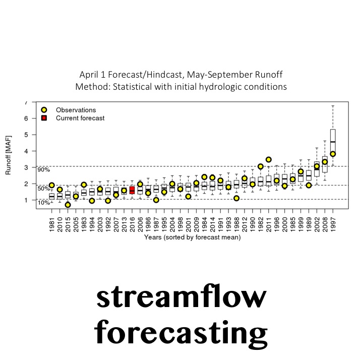
Climate and hydrologic applications for water resources planning and management—such as climate impact assessments and streamflow forecasting—commonly neglect important sources of uncertainty, especially those associated with internal climate system variability, downscaling methods, and hydrologic modeling. Too often resources are limited and tools are unavailable to evaluate more than a single source of uncertainty (e.g., using multiple global climate models). As a result, evaluations of future risk may be over-confident.
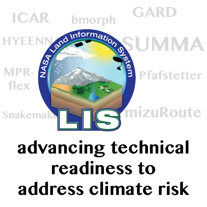
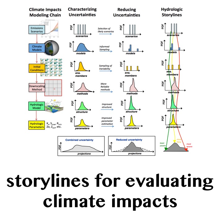
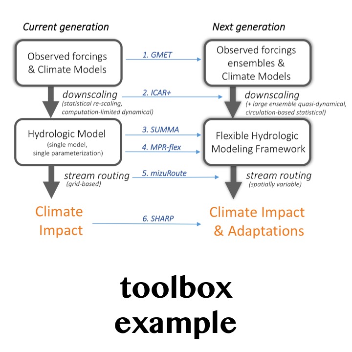
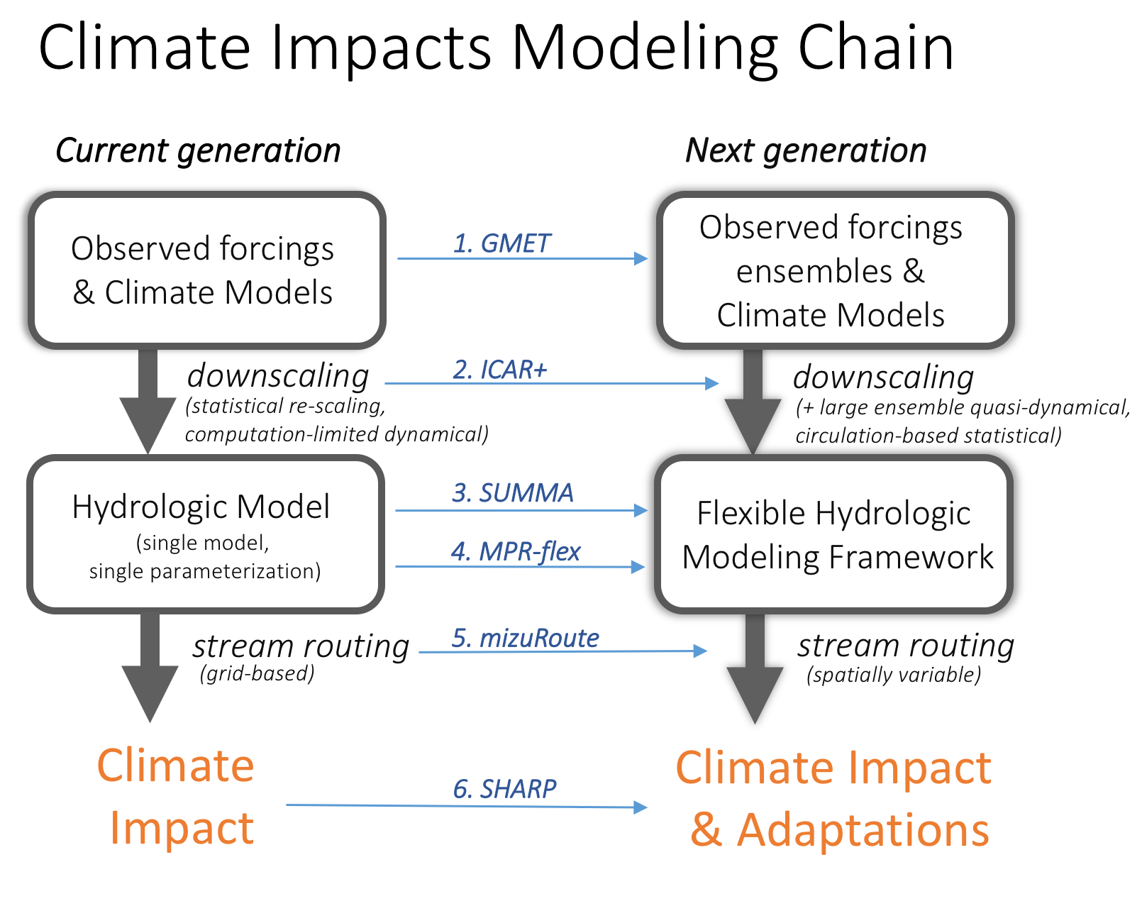
Scientists and engineers in RAL’s Hydrometeorological Applications Program at the National Center for Atmospheric Research are collaborating with the U.S. Army Corps of Engineers, the Bureau of Reclamation, and the University of Washington to build tools that will help to characterize uncertainties in climate impacts assessments at each step of the modeling chain. Through developing improved methods, models, and datasets (illustrated in the figure), this research improves the fundamental building blocks on which hydrometeorological analyses and applications depend. It also, importantly, provides useful tools and data resources for both researchers and practitioners to better reveal climate change risks and more effectively evaluate future change and adaptation options.
Each research component (blue text in the figure) advances our knowledge independent of the others, and collectively they provide a strong foundation for understanding and adapting to future change, servicing multiple needs for multiple users.
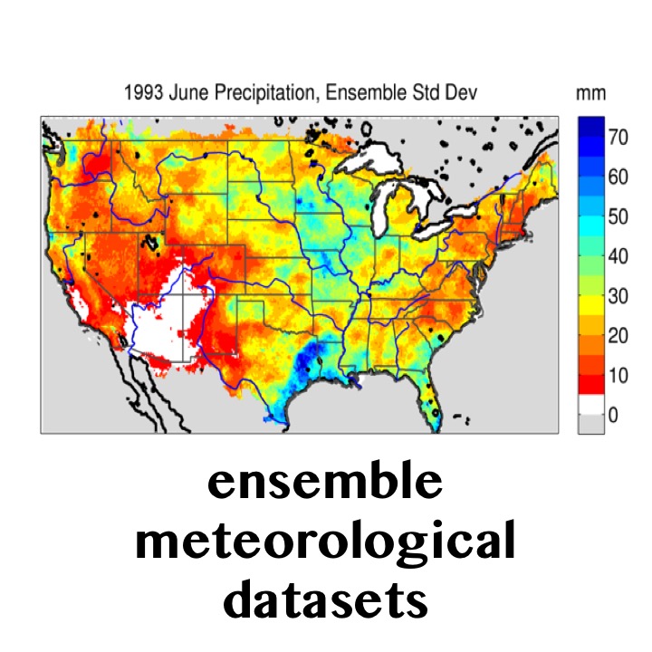
Gridded meteorological ensemble tool (GMET): Generates high-quality, probabilistic gridded meteorological fields that can be used to quantify uncertainty of meteorological forcings useful for climate model evaluation, hydrologic model parameter estimation, and hydrologic data assimilation.
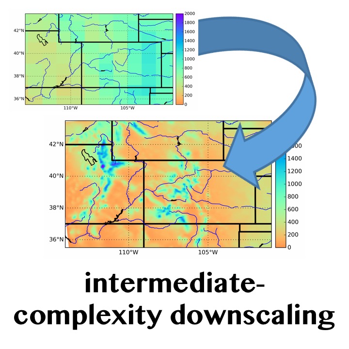
Intermediate Complexity Atmospheric Research (ICAR) model: a quasi-dynamical downscaling approach that uses simplified wind dynamics to perform high-resolution simulations 100 to 1000 times faster than a traditional atmospheric model and can therefore be used to better characterize uncertainty across climate models and in dynamical downscaling.
Structure for Unifying Multiple Modeling Alternatives (SUMMA) framework: a new hydrologic modeling framework that provides multiple options to simulate all dominant biophysical and hydrologic processes from the treetops to the stream, and is particularly useful to characterize model and parameter uncertainty in hydrologic model simulations.
Multi-scale Parameter Regionalization Flex (MPR-flex): a model-independent, flexible parameter estimation application that enables continental-domain application of multiple hydrologic models in a spatially consistent way.
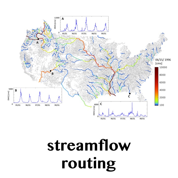
mizuRoute: a multi-method, continental-domain routing model that efficiently routes streamflow from any distributed hydrologic model through river networks, not just changes on a grid. It has been used to provides streamflow values at 54,000 river segments across the contiguous United States.
System for Hydromet Analysis Research and Prediction (SHARP): an integrative prediction framework that leverages the methodological advances outlined above to evaluate climate impacts and adaptation options, developed by using real-time demonstrations of streamflow predictions.
These scientific advances provide a new way to characterize climate impacts on water resources by:
Moving to large ensembles: this effort, through the collection of tools outlined above, enhances the water resource research community’s ability to generate large ensembles that comprehensively characterize uncertainties and better reveal undiscovered risk.
Generating hydrologic storylines: large ensembles, while important in revealing uncertainties, can be computationally impractical in applications. As such, there is work underway to distill future scenarios into a discrete set of quantitative hydrologic “storylines” that represent key, impact-focused, features from the full range of scenarios.
Providing resources for the entire Nation: these tools provide consistent, continental-domain datasets and are currently being implemented in Alaska and Hawaii.
Issuing guidance for appropriate use: these tools and datasets will be publically available and will be accompanied with documentation for how to use them to support adaptation planning and decision making.
NCAR: Martyn Clark (PI), Ethan Gutmann (Co-PI), Andy Wood (Co-PI), Andy Newman, Naoki Mizukami, Julie Vano
University of Washington: Bart Nijssen
U.S. Army Corps of Engineers: Jeff Arnold
Bureau of Reclamation: Levi Brekke, Ken Nowak
Contact: Martyn Clark - mclark@ucar.edu | Julie Vano - jvano@ucar.edu
U.S. Army Corps of Engineers, Bureau of Reclamation
3450 Mitchell Ln
Boulder, Colorado 80301
United States