Overview:
The VAPOR Image panel supports the visualization of a 2D image in the VAPOR 3D scene. The image can be positioned on a vertical or horizontal plane in the scene. If the image is horizontal it can be mapped to the terrain. The following illustrates a typical application of VAPOR Image visualization:
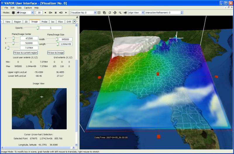
In the above screenshot, the Image panel is being used to display an image of the earth's surface (near Georgia) and also an image of US county boundaries. Both of the images were obtained using the VAPOR utility getWMSImage.sh. The county boundary image is positioned above the terrain image so that both can be seen together, making use of the transparency in the boundary image. Above the two image displays is a 2D data partially transparent surface of the 2D variable SLP. Also shown is a white isosurface of T (indicating a cold air mass to the northwest of Georgia) and a volume rendering of the QVAPOR variable, indicating increased water vapor along a ridge in northern Florida.
Image Capabilities:
The following are the capabilities of the Image renderer
- The image to be displayed must be specified in a tiff or tms file.
- If the tiff file is georeferenced, then VAPOR will position the image at the correct horizontal location. The VAPOR supported map projections are described under geo-referencing.
- Horizontal images can be applied to the terrain, and displayed at a height above the terrain, as specified by a 2D "Height" variable.
- Vertically oriented images can be displayed as well, however such images must be manually positioned at the desired location, as there is no georeferencing for these.
- The 2D Image manipulator can be used to specify the location in the scene to position the image
- Multiple partially transparent images can be stacked in the scene and visualized together, by specifying different z-coordinates for each image.
- Animated image sequences can be shown in the scene and animated with the data, by including the images in a multi-image geotiff file.
- A few pre-installed images are provided with VAPOR, providing images of the earth's surface or political boundaries.
- When in 2D mode, a cursor can be used to identify coordinates in the image, and can identify lat/lon coordinates if the image is georeferenced.
- The cursor point can be used to specify flow seed points, and to center the Region, the View, the Rake, and the Probe.
- Oceans can be made transparent to show sub-surface data by unchecking the "Ignore image transparency" box (release availability: version 2.5.0 and beyond)
Georeferenced image sequences (geo-tiffs) can be created in NCL and displayed or animated in the VAPOR GUI. This capability is described in the tutorial "Using NCL with VAPOR to Visualize WRF-ARW data".